El Niño

El Niño is at Our Doorstep: World Expecting the Great Storm
Forest fires, high temperatures and typhoon. This is what will happen in December, according to meteorologists, when El Niño, which is centered on reversing water temperature, will occur. Prof. Haim Kutiel from Israel explains
What is the El Niño?
The El Niño, a climate phenomenon that is essentially an abnormal heating of the eastern equatorial Pacific Ocean waters, which causes extreme weather changes in the coast and in other places around the world.
The name El Niño (in Spanish: “the boy”) was invented by local fishermen to describe the hot current that appears in Peru’s and Ecuador’s beaches every year in December, around Christmas – the day Jesus Christ was born, according to Christianity. Usually, the raise in water temperatures is not significant and the warm currents disappear during March, and at the beginning of April. Nowadays, the phenomenon called El Niño applies only to the years when a drastic increase in sea water temperature for a longer number of months.
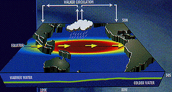
In ordinary years, sea water that has been heated by strong sunlight at the equatorial region concentrate at the western part of the ocean
What do the meteorologists say?
According to water temperatures in the Pacific Ocean, this could certainly happen. The storm will affect many parts around the globe. According to all the precursors today, three months before the phenomenon’s peak, the temperatures are 4-5 degrees higher than the seasonal average, and one of the strongest El Niño incidents is expected.
The El Niño is the peak of the overturning of sea water temperatures. Usually, the Pacific Ocean has a water and air flow from South America to Australia’s a result, there is a lot of evaporation near Australia, as well as many precipitations, whilst South America is dry. Every few years, the situation is reversed – the water in South America, near Peru and Ecuador’s beaches get a lot hotter, 3-4 degrees and sometimes even 5 degrees higher. As a result, the flow changes its direction and start going from Australia towards South America.
Effect on large areas around the globe
These are tens of millions of square kilometers of ocean water where the temperatures are several degrees higher. This increases the heat reserve, and as such, El Niño’s consequences will be reaching a lot farther than between South America’s and Australia’s beaches, and some of the consequences will be significant in large areas across the globe.
The expectation is one of the strongest El Niño happenings to date. There have been such incidents that have started as strong ones but faded quickly, however, according to the Australian meteorological service, this El Niño will peak in December, and may be one of the strongest, if not a record-breaking one, but it will weaken significantly after 3 months.
Floods are expected in South America, as well as soil erosion that will damage agriculture. Simultaneously, the phenomenon might cause droughts, forest fires, and severe heat in Australia and Southeast Asia, as well as a larger number of typhoons in the Pacific Ocean due to the very small heat reserve. However, the Atlantic Ocean experiences less typhoons during El Niño years.

